* Addresses #478, adding a heading class to represent headings and angles
Removed some unused code

* Fixing bad merge

* Formatting

* Fixing type issues and other merge resolution misses
An HTN (https://en.wikipedia.org/wiki/Hierarchical_task_network) is
similar to a decision tree, but it is able to reset to an earlier stage
if a subtask fails and tasks are able to account for the changes in
world state caused by earlier tasks.

Currently this just uses exactly the same strategy as before so we can
prove the system, but it should make it simpler to improve on task
planning.
This is as much as we can do until pydcs actually adds the py.typed
file. Once that's added there are a few ugly monkey patching corners
that will just need `# type: ignore` for now, but we can't pre-add those
since we have mypy warning us about superfluous ignore comments.
- added information about the role of the aa site
- moved handling of ground name from tgo to the sam generator to make the tgo cleaner
- adjusted the skynet-config lua to the changes
Target the air defenses whose *threat ranges* come closest to friendly
bases rather than the closest sites themselves. In other words, the
SA-10 that is 5 miles behind the SA-6 will now be the priority.

This also treats EWRs a bit differently. If they are not protected by a
SAM their detection range will be used for determining their "threat"
range. Otherwise a heuristic is used to determine whether or not they
can be safely attacked without encroaching on the covering SAM.
We don't need to include a SEAD flight in missions against EWRs or SAMs
that no longer have a radar.

Also plan DEAD missions against air defenses that have no radars.
Previously we would never finish killing launcher only sites (which
cannot defend any more, but are cheaper to return to working order than
a fully destroyed site) nor would we plan DEAD against IR SAMs or AAA.
We were setting up all the correct *target* waypoints but the AI doesn't
use the target waypoints; they use the targets property of the ingress
waypoint. This meant that the flight plan looked correct in the UI and
was correct for players but the tasks were set up incorrectly for the AI
because building TGOs are aggravatingly multiple TGOs with the same name
in the implementation.

Mission targets now enumerate their own strike targets so that this
mistake is harder to make in the future.

This won't be perfect, the AI is still not able to parallelize tasks and
since buildings aren't groups they can only attack one structure at a
time, but they'll now at least switch to the next target after hitting
the first one.

As a bonus, stop bombing the dead buildings.

Fixes https://github.com/dcs-liberation/dcs_liberation/issues/235
Fixes https://github.com/dcs-liberation/dcs_liberation/issues/244
This really needs to be a proper type, but this is a start: create new
categories for the types of TGOs that are missing. This removes some
icon special cases.
These are an implementation quirk, and passing them to the UI just means
that we put TGO pins on top of the CP, which makes the base menu
unopenable.

In the old UI we avoided this by not drawing anything that was
`for_airbase`, but now that we can zoom in further we're drawing base
defenses.
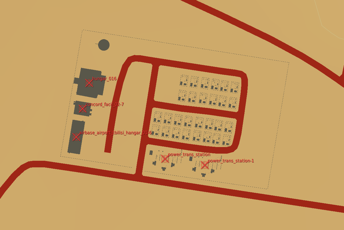
This PR allows campaign creators to incorporate map objects (referred to as Scenery in the code) into their Liberation campaign.
Map objects are defined using white trigger zones created by right clicking on scenery and clicking `assign as...`. Objective groups are defined by creating a blue TriggerZone surrounding the centers of the white trigger zones. The type of objective is determined by the campaign creator, assigning the value of the first property of the blue TriggerZone with the objective type.
Map objects maintain their visually dead state by assigning a `Mission Start` `Scenery Object Dead` trigger to the trigger zone. It is important for the Liberation generated TriggerZone to be as small as possible so that no other scenery is marked dead by DCS.
TriggerZones are hidden during gameplay (DCS behavior. I don't know if it's possible to turn that off.) TriggerZones are visible in the mission editor and mission planner however. If a player is using an older plane, it is important for them to remember where the target is.
In the mission planner, the trigger zones' will be blue or red depending on which faction the map objects belong to.
Inherent Resolve campaign has been modified to integrate scenery objects.
### **Limitations:**
- Objective definitions (Any Blue TriggerZones) in campaign definition cannot overlap.
- Map object deaths in `state.json` is tracking integers. You won't know what died until debriefing.
- No images for the various buildings. In theory it can be done, but an unreasonable amount of work.
- Every blue trigger zone must have a unique name. (If you let DCS auto increment the names this is not a concern.
- No output to screen when scenery object is dead. You can see the building drawn as dead in the F10 map though.
### **Pictures:**
An objective:
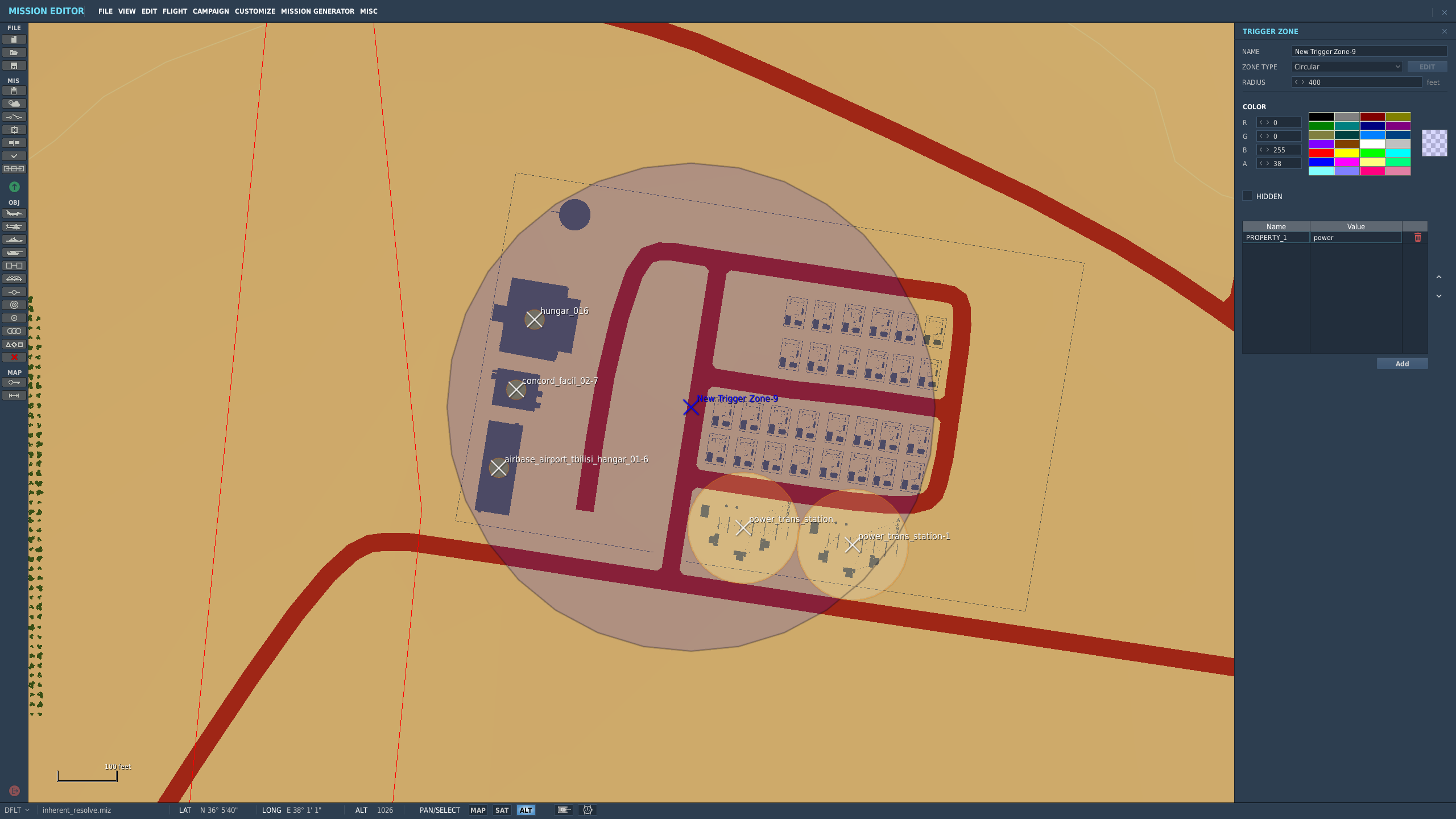
How the objective looks once in the mission planner/editor. This objective belongs to the enemy faction:
The `FactoryGroundObject` is just a special case of
`BuildingGroundObject` that we maybe don't actually need. For now it
provides some special case logic for the layout, but this allows any TGO
with the "factory" category to behave as a ground unit source.

Note that the "factory" random strike targets are *not* generated
anymore, so this doesn't affect campaign design currently.
This also removes the "factory" type from the normal strike target
(money generating) generators to avoid confusion. Later only control
points with factories will be able to spawn ground units, at which point
these will no longer generate income.

https://github.com/Khopa/dcs_liberation/issues/986
* A Bluefor EWR 55GS in the campaign miz defines an optional EWR site. There is no distinction between how close or far it is to a base, so it's possible that there will be many EWRs within an airbase.
* A Redfor EWR 1L13 in the campaign miz defines a required EWR site.

It would be a good future idea to limit the amount of EWRs within a certain distance from an airbase. That way there's no chance of 5 EWRs all at the same airbase. Even better if there were something preventing any two EWRs from being right next to each other.

No campaigns take advantage of this yet.

Fixes https://github.com/Khopa/dcs_liberation/issues/524
We were never resetting the dead state for repaired SAMs. Rather than
tracking that manually, determine liveness from the number of units left
alive.

For building objectives where the group is not assigned to the TGO until
*mission* generation time we still need manual tracking.
Some SAMs have multiple groups (such as an SA-10 group with its
accompanying SA-15 and SA-19 groups). This shows each group's threat and
detection separately on the map, and also makes it so that an SA-10 with
dead radars will no longer contribute to the threat zone just because
the shilka next to it still has a functioning radar.

https://github.com/Khopa/dcs_liberation/issues/647
Fixes https://github.com/Khopa/dcs_liberation/issues/672
Creates threat zones around airfields and non-trivial air defenses (it's
not worth dodging anything with a threat range under 3nm). These threat
zones can be used to aid mission planning and waypoint placement.

https://github.com/Khopa/dcs_liberation/issues/292
When a base is captured we clear its defenses. Those locations need to
be returned to the preset location pool so they can be used for the new
base defenses.
Like with deleting waypoints, these will degrade the flight plan to the
2.1 behavior.

Ascend/descend points aren't in use any more, so I removed those.